NCI has been a core part of delivering the Australasian Copernicus Regional Data Hub (the Hub) alongside Geoscience Australia for the past five years. Operated by Geoscience Australia on behalf of the Australian government and state government partners, NCI is the service provider, handling the data storage, ingest and distribution infrastructure for the Hub. The Hub has been a game-changing data sharing initiative for environmental management and Australian data management expertise.
Data in the Copernicus Hub is collected by a constellation of Sentinel satellites from the European Union’s Space programme, orbiting the Earth and imaging the ground and the oceans with an array of different cameras and instruments. The Australasian and Pacific portion of the complete data set, covering almost a quarter of the globe, makes up the 6 Petabytes of the Hub, and is constantly updated with new images streaming down every day. Getting this data to Australia from their European headquarters has been one of the largest single data transfer projects ever undertaken in Australia. The collection is growing at a rate of around 3 Terabytes per day, or one Petabyte per year.
Copernicus data is used by Geoscience Australia, land management agencies, environmental scientists and state governments to understand the condition of our region’s landscape. It is helping us understand soil moisture contributions to bushfire risk, year-on-year changes to the Australian coastal landscape and even underground mineral resources. The opportunities and potential for incorporating this data into operational practices are huge.
Geoscience Australia Hub Engineer Mike Peters says, “One of the biggest achievements of the Hub over the past five years has been to establish a robust data sharing and data management model for the Earth observation community. The Hub is a continuation of decades of Earth observation in Australia going back to the 1970s, and it has become an incredible resource for science and environmental management around the country.”
State Governments are now using Copernicus data as a source of the latest, high-quality environmental information for use in the operational monitoring of land clearing, bushfire regrowth and drought management. The success of the Hub highlights the demand for Earth observation data, and just how impactful it is to have a centralised, well-managed repository of research collections in the Australian region.
With the Hub’s steering committee agreeing to continue the Hub for another five years, Geoscience Australia and NCI are now preparing for the next generation of the Hub, with modern best-of-breed software platforms replacing the original legacy system. Together, the two organisations have built not just a data repository but a model for public access to research data for users in Australia and across our region.
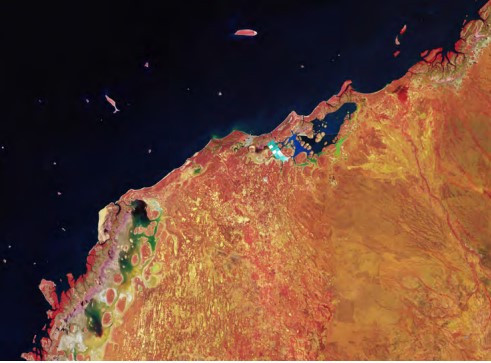
The northern coast of the Pilbara region in Western Australia, captured by the European Union’s Copernicus Sentinel satellites and processed by the European Space Agency. (ESA, CC BY-SA 3.0 IGO). Thank you to Dr Mike Peters, Dr Michael Hope (Geoscience Australia) and Andrew Howard (NCI) for their input into this case study.